High-Resolution Terrain Mesh and Scenery Enhancements for Southeastern British Columbia, Canada
|
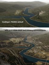
Click a screenshot to view full-size version
High-Resolution 76-m (LOD9) Terrain Mesh and Scenery Enhancements for Southeastern British Columbia, Canada
The files in this package contain a high-resolution terrain mesh and scenery enhancements for the mountain ranges of southeastern British Columbia and parts of the Alberta Rocky Mountains. Coverage extends from Penticton to Creston, and McBride to Hinton, Alberta (N48.9-53.4 W116.3-120.2). The mesh source data are 3-arcsec (~90-m) Shuttle Radar (SRTM) files, compiled and edited in MicroDEM and resampled to LOD9 (76 meters resolution). All lake elevations (!) have been adjusted to eliminate the problems with the default lake data and to better fit the new terrain mesh. In addition, the Columbia/Kootenay/Pend Oreille River corridor between Nelson, Castlegar, and the US border has been partially re-made, with new shorelines, hydroelectric dams, transportation network, and landclass updates based on satellite imagery. The western edge of this terrain mesh coincides with the eastern boundaries of my previous LOD9 mesh files of southwestern B.C., bcmesh9a.zip and bcmesh9c.zip (Note that bcmesh9b.zip is being replaced by this new and extended file).
Castlegar (CYCG), Nelson (CZNL), and Trail (CAD4) are the three airfields in the special 'enhanced' area; other places to start scenic flights from in the mesh coverage area are Kelowna (CYLW), Salmon Arm (CZAM), Revelstoke (CYRV), Blue River (CYCP), Valemount (CAH4), and Jasper (CYJA).
|
  |
© Copyright 2003-2024 FlightSimHQ.com & its owners. All rights reserved.
Terms of Use |
Privacy Policy |
Advertise with us |
Submit News |
Contact us |
Twitter