


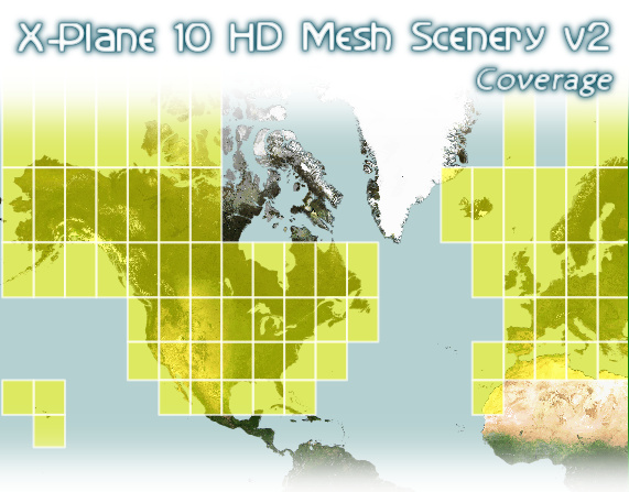
The free (donationware!) X-Plane 10 HD Scenery Mesh v2 has been released after almost a year of work. It covers many of the "interesting" regions of the planet (over 55 Gbytes of data), covering:
- Europe (Iceland and Canaries included)
- USA (Hawaii included)
- Canada (most parts of it)
- Alaska
It is an update to the older v1 HD Mesh (and a replacement of the default Global Scenery) and brings a lot of improvements to the simulator:
- It is a much higher resolution base mesh (more, smaller triangles) compared to the default Global Scenery which ships with X-Plane 10 (one could say: approximately 2-3-times more dense)
- The higher resolution mesh allows for a much more detailed representation of the elevation profile of the landscape
- The higher resolution mesh allows a much more detailed/exact representation of the underlying landclass data (because of the smaller triangles, which can follow landclass changes in the raw data more closely)
- It is based on a completely new Openstreetmap (OSM) data (approximately end of September 2013), which brings (compared to default Global Scenery) a lot of improvements in:
- water features (lakes, rivers, coastline) - many previously missing water features are now finally there
- roads
- railroads
- power lines
- urban park areas
- water features (lakes, rivers, coastline) - many previously missing water features are now finally there
- It includes line rivers from OSM (not just polygons as before) tagged waterway=river which improves the landscape in most regions quite a bit
- Uses improved urban zoning (thanks to improved algorithms in the scenery generator)
- Many smaller and larger landclass data improvements
- completely replaced the landclass data for Canada (big improvements)
- improved forest density representation in Europe (changed the sparse / dense classification)
- some new classes added (in many regions), like: moraines, riverbeds, mining/dump sites
- added differentiation between ice (perennial) and snow (more temporal) to have an even more detailed representation of mountains
- dded differentiation between irrigated / non-irrigated crops (in some regions - like the USA etc.)
- completely replaced the landclass data for Canada (big improvements)
- Completely replaced the elevation data with viewfinderpanoramas.org (if yew have a few cents, donate to that guy!). This doesn't changes much in areas which were already great, but fixes some which were really hosed.
A large selection of screenshots can be found here:
- Europe: https://picasaweb.go...feat=directlink
- North America: https://picasaweb.go...feat=directlink
I would recommend you to start with 1 or 2 smaller regions first. Install it, test it, and only then come back later for more. Don't expect to have all of the scenery at once!
http://www.alpilotx....cenery-mesh-v2/
And a I would to thank www.flightsim.com for making it possible to host a project of this size!
Andras Fabian
www.alpilotx.net


